On Saturday 10th September, the Society led a walk of around 3.5 miles around the historic village of Bradbourne and the surrounding areas including Wigber Low. There was a great turn out from Parwich locals and Society members and the weather was stunning.

Bradbourne – a brief history
When the Romans left the area in the 5th century, the Anglo-Saxons moved in, with the Trent basin at the heart of the new Kingdom of Mercia, and this part of Derbyshire becoming its frontier zone. In 653 Christian missionaries entered Mercia and following the conversion of the Royal family, they founded mission centres such as Repton and Wirksworth.
The cross in Bradbourne churchyard depicts the Crucifix and is adorned with tracery typical of the handful of decorated Saxon stone crosses dating from around 800 which still survive in North Derbyshire. These crosses were erected as Christian worship spread into the frontier zone prior to the building of the Saxon church.

This spread of religion was halted by the Danish conquest of part of Derbyshire in the 9th century. The area was regained by the English under Alfred the Great’s son King Edward the Elder of Wessex, during his campaigns of 917 – 921. To hold the northern countries against Norse attacks, Edward established supply lines and chains of royal estates with his headquarters at Bakewell. Bradbourne, Ballidon and Brassington lie in the middle of the chain connecting Matlock on the River Derwent to Ashbourne on the Dove. Ballidon was a royal estate until given by King Edgar to Thane Aethelfrith, Bailiff of the Western Peak, in 963.
William the Conqueror valued the strategic importance of these chains of estates and gave Bradbourne and Brassington to his friend Henry de Ferrers who built the church at Bradbourne. These Norman Lords were very conscious of the need to save their souls and in addition they built chapels of ease on the outlying parts of their estates for the Priest to visit and say Mass. Bradbourne had four chapels at Ballidon, Brassington, Tissington and Atlow. About 1100 the manor and church of Bradbourne were given to the Caus family and in 1205 they gave the Church to the Priory of Dunstable. With the church went the four chapels, church lands, mineral and grazing rights. Later Dunstable successfully petitioned the Bishop of Lichfield to secure title to the rectory and the tithes that went with it.
After the dissolution of the monasteries all these lands went to the Crown and were sold off. Following the Reformation the ties between Bradbourne and its churches were loosened. Atlow and Tissington eventually went separate ways, Brassington became a parochial chapelry in 1726, then a separate parish, building its own vicarage in 1857. Now Bradbourne, Ballidon and Brassington are again held together as part of the Wirksworth Team Ministry.
(Information courtesy of Bradbourne Church)
Bradbourne is listed in Domesday book as one of the many manors appropriated by Henry de Ferrers after the Norman conquest:
“In Bradbourne, Aelfric had 4 carucates of land to the geld. [There is] land for 4 ploughs. Now in demesne [are] 2 ploughs; and 12 villains and 4 bordars have 4 ploughs. There is a priest and a church, and 12 acres of meadow, [and] scrubland 3 furlongs long and 2 broad. TRE worth £4; now 30s.”
“In Tissington … 1 mill [rendering] 3s…”
- bordar = cottager
- carucate = area of ploughland able to be ploughed by a team of 8 oxen
- geld = land tax
- TRE = Tempore Regis Edwardi, i.e. before 1066
- villain = villager (higher status than bordar)
Bradbourne church
We were welcomed by Church Warden Eddie, who provided an excellent and informative tour of the church and its grounds, sharing his wealth of local historical knowledge and interesting insights.

The origins of All Saints are Saxon. A Norman Tower and chancel were added in the early 12th century and over the next 500 years alterations took place in various styles of gothic architecture. The oldest surviving part of the building is to be seen on the outside of the church north side. There are long and short quoins at the northeast corner of the nave and these together with the adjoining masonry appear to be late Saxon work of the early 11th century.
The massive Norman tower has three stages, its size indicating the importance of this church during the 11th and 12th centuries. The belfry has twin openings on the south side with an archway decorated with chevron and billet mouldings. Above the belfry storey are Norman corbels of small human heads, which probably supported a low pyramidal roof.

In 1205 the church was given to the Priory of Dunstable and soon after the Norman chancel and nave were enlarged in the Early English style. Later in the 13th century or early in the 14th the splendid Norman doorway was moved from its position as the main entrance into the nave to its present position at the foot of the tower. This door has the outer order of its arch carved with a simplified beak-head design and the inner two various birds and winged animals. The Norman door was moved to enable a south aisle to be added in the Decorated Style.

The three bay arcade is remarkable for its short, massive pillars, which are a slightly pointed quatrefoil shape.The present windows in the south aisle are later but the hood mould of the easternmost window can probably be dated to this period (1340) because it is terminated with carvings of a King and Queen’s head believed to be those of Edward III and Philippa.

Over the next 150 years the alterations in the Perpendicular style included a number of windows. The nave roof was removed and the clerestory windows and parapet added. The outside of the church as it now stands is much as the builders left it around 1550 apart from the 19th century vestry and organ chamber. Internally most of the ancient furnishings and plaster work have been removed but there is an old font, of uncertain age.
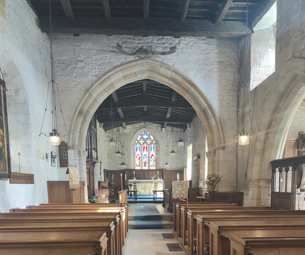
The fourth oak panels, which are fastened to the later screen in the south side aisle are something of a mystery. They are obviously parts of a larger work and may be of Scandinavian origin. The north window of the chancel contains some fragments of 14th and 15th century glass. In the south aisle is a primitive 16th or 17th century wall painting of towers surrounding a black letter quotation from Ecclesiastes (5:1). The church also contains an early 17th century painting of the Adoration of the Shepherds.
There are so many more stories and insights that Eddie shared with the group on the day, which made it even more special. The Society would like to extend its thanks once again to Eddie, a treasure trove of local history!
(Information courtesy of Bradbourne Church)
Bradbourne Hall
The estate surrounding Bradbourne Hall as it is seen today has always been attached to the Bradbourne Priory. The remaining building of which is the All Saints Church. Throughout the 12th Century, the church and surrounding buildings were rebuilt and extended, and during the 13th Century large scale reconstruction work took place.
1205, Geffrey De Caus who at the time held the land the Hall stands on today, gave it to Dunstable Priory who farmed the limestone hills of the district.
Bradbourne Hall stands on the site of the rectory for the church, and whilst the exact date the rectory was built is unknown, it is known to have existed by 1278. At one point, 3 canons from Dunstable Priory resided at Rectory whilst serving parishes of Bradbourne, Brassington, Tissington, Ballidon and Atlow.
During the dissolution of the monasteries 1536-1541, Dunstable Priory and lands were forfeited to the Crown, where Sir Walter de Ferrers was given the Church and glebe lands (240 acres).
The land and later the advowson of the rectory was sold to George Buxton in 1609. Buxton demolished the Rectory and in 1610 constructed Bradbourne Hall for his personal occupation. The advowson of the Rectory meant that his family held cleric positions within the parish for the following centuries.
Ancestor George Buckston who died in 1810, changed the family surname spelling from Buxton to Buckston. His son Rev. George Buckston was vicar of Bradbourne 1803 – 1826, who was in turn succeeded by his son Rev. German Buckston who held the position until 1861. Rev German Buckston married Ellen Ward, the daughter of the vicar of Sutton on the Hill, and when her father died in 1834, Rev. German Buckston moved to Sutton on the Hill to take up his position.
Following his departure in 1834 and up to 1910, Bradbourne Hall was occupied by numerous tennants. These were not recorded in detail but included:
- Colonel David Wilkes, (4th Bengal Native Infantry) who was involved in the 1859 Indian Mutiny.
- Albert Hartshorne, archaeologist and author and his wife Constance, remained in the Hall until his death in 1910.
In the 1920’s the Hall was sold to L.W. Hodson, and was extended and altered in 1929 and remains a private house and residence today and is not open to the public.

Bradbourne Mill
From the village of Bradbourne, we headed down the road and took a public footpath on the left taking the group across open fields down to the bridge crossing the water at the back of Bradbourne Mill. Heading down the hill again the group headed to the entrance of the Mill located on the main road opposite the Tissington Ford.
The buildings at Bradbourne Mill comprise the mill itself, the miller’s house plus two barns or stables now converted to holiday accommodation.
The mill is the oldest surviving water mill in Derbyshire. It was built in 1726 and continued in operation until the 1920s. However, the mill settlement dates back even further: Roman coins (dated to the reign of Antoninius Pius, 138-161AD) and a shard of Roman pottery have been found at the property.
The earliest historical records for the mill date back to 1180 when it was held by Geoffrey de Caus, great grandson of Henry de Ferrers (one of William the Conqueror’s sidekicks). The Bradbourne family were the first recorded tenants. In 1247, Sir Robert de Bradbourne rented the mill to three canons of Dunstable Priory who built a Manor House and Grange buildings in Bradbourne near to All Saints Church; the canons having been gifted the church, four chapels, and the parish lands in Bradbourne, Tissington, Baildon, Brassington, Atlow in 1205.
In 1330, Sir Roger de Bradbourne granted the use of Bradbourne Mill to the Dunstable Priory canons for the princely sum of “a single red rose each year on St John the Baptist Day [June 24th]”.
In 1540, following the dissolution of the monasteries, the tenancy of the Mill returned to the Lord of Bradbourne (Sir Humphrey de Bradbourne, Senior).
In 1594, William de Bradbourne II sold the Manor of Bradbourne and the Mill to his brother-in-law, Sir Humphrey de Ferrers and sister Ann de Bradbourne (Sir Humphrey’s wife).
1749: Lord George Marquess of Townsend acquired the mill through his marriage to Lady Charlotte Compton, 16th Baroness Ferrers of Charterley.
1809: Marquess George Townshend sold the mill to Sir Phillip Gell of Hopton Hall.
1837: Another descendant of the Normans, Sir William Fitzherbert, purchased Lea Hall and Bradbourne Mill. This comes with the ancient title of Lord of the Manor of Bradbourne (but not the manors land or buildings).
2006, Mill sold by Sir Richard Fitzherbert.
The mill itself is well worth a visit and you can see more about the Society’s guided tour inside the Mill here. Power is supplied via two mill wheels, one iron, one wooden. The older mill wheel probably dates back to 1625-1630 (the age of the mill workings at the property). The newer mill wheel belongs to the probable upgrade in 1800 to 1850.
Many of the mill workings themselves can be seen inside the mill, including hoppers to load the cereal, four pairs of millstones, and the solid oak framework holding the various gears that convey the power generated by the mill wheels to the mill stones.
A mill race directs water from Havenhill Brook. (A timber sluice gate found in the mill race has been carbon dated to between 1424 and 1560.)
Beneath the mill kitchen is a kiln which was used to dry out the cereal before milling. A kiln tile found at the mill has been dated to between 1533-1630.

Diagram showing a typical mill working (from Weald & Downland Living Museum, West Sussex)
Watermill from Lurgashall – Weald & Downland Living Museum (wealddown.co.uk))
Bradbourne Mill References
The Water Mill – Holiday Cottage in the Peak District (thewatermill-bradbourne.co.uk)
Historical Timeline | The Water Mill (thewatermill-bradbourne.co.uk)
Bradbourne Mill (bradbourne history.co.uk)
[Henry de Ferrers – Wikipedia]
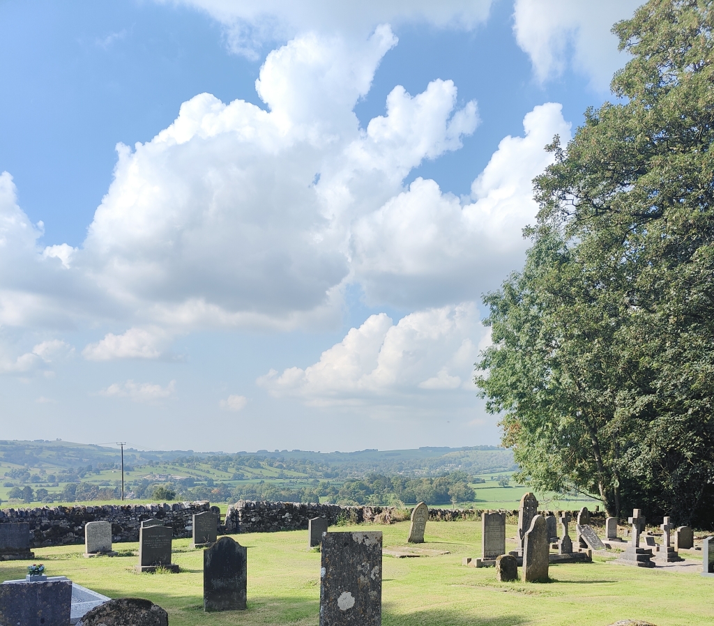
Wigber Low
Tracing our steps back from up the hill from the Mill we climbed the trail path eventually reaching the top of the mound at Wigber Low, for a well earned sit down and refreshments.

From this vantage point we could see across the valley to Parwich in the distance.

The name Wigber Low is thought to mean ‘Wicga’ barrow or burial mound…’Wicga’ being an ancient Anglo-Saxon name, and ‘Low’, also Anglo-Saxon, meaning small hill, usually also refers to a burial mound.
Before the creation of what is now the B5056, as a toll road in 1811, the main route from Parwich to Ashbourne market would have been the ancient trackway that goes up from the Tissington Ford over Wigber Low and on through Kniveton.
There are signs of domestic occupation just below the summit from the Neolithic period onwards.
In the early Bronze Age a stone platform was built on top of the ridge. Described as an excarnation platform by archaeologists, this was used for ‘sky burials’. Also followed by some North American Indians and Tibetans, in this practice the dead body is exposed to the elements and wildlife until the flesh is cleaned from the bones, which are then taken for burial elsewhere or for other ritual uses.
In the later Bronze Age the platform was covered in a more conventional burial mound in which cremations or bones could be inserted. It is possible that such funeral sites, as well as creating a spiritual landscape, also served as a form of title deed: i.e. this land is ours because our ancestors dwell in this sacred place.
Little is known about the Iron Age occupants of the White Peak in the first centuries BC. Being in the border country between the Brigantes and Coritani, two of the tribes of Celtic Britain, it may be that here the population was fairly thin on the ground. However, under Roman rule in the second century AD onwards, the White Peak was administered as a single unit to exploit the lead found here. At this time the archaeology indicates shepherds were living and working on this hill. Presumably they were native Britons, but also over a span of centuries Romans coins were inserted into the stones of the mound. It is interesting to speculate whether these coins were left by the native shepherds or by Roman visitors, either passing on the Street, the Roman road running through Brassington and Longcliffe, or coming from Lutadarum, a lost Roman ‘town’, perhaps now under Carsington Water.
After the collapse of Roman Britain, various pagan Anglo-Saxon tribes came together to create various kingdoms, the White Peak being in the northern part of Mercia. In the mid 7th century four Celtic priests from the Northumbrian monastery of Lindesfarne began the process of converting the Mercians to Christianity. It is believed that one of the four, Betti, came to Wirksworth founding the church there.
Also at this time 9 Anglo-Saxon graves were inserted into the Bronze Age mound at Wigber Low. Some were high status graves of members of the eorlas or warrior elite buried with their swords and valuable grave goods. Others include a male aged 45-50 years old buried with a spear and dagger and a female of around 25-30 with a sword lying between them, and a further grave with a child of around 5 years, to which a woman of around 17-25 was added later.
Interestingly in a pre-Christian site, the grave goods, decorated with both pagan and Christian symbols, indicate that their owners were hedging their bets in matters of religion. Perhaps one of these graves belongs to Wicga after whom the hill is named.
In the Medieval period, making use of the hill top air currents to create higher temperatures, Wigber Low was used for lead smelting. In the fields around Wigber Low you can see the ridge and furrow of Medieval ploughing, but on the top of the ridge the soil is not deep enough to grew crops. Finally, before the significant excavation of the 1970s by the University of Sheffield, there had been some archaeological exploration of the site in the nineteenth century by John Fossick Lucas of Fenny Bentley, who found a range of Anglo-Saxon metal work, including a sword.
The sight has always been of historical interest and excavations took place in 1841, 1869, and 1975-76.

Wigber Low References
Wigber Low (wondersofthepeak.org.uk)
Wigber Low – Andrea Gibbons (writingcities.com)
Lea deserted village
From the summit of Wigber low looking to the east and west you can see fine examples of ridge and furrow.
Ridge and furrow was created by the ploughing technique in medieval times, with a single plough blade which tipped the soil to the right and a team of oxen walking clockwise. Every third or fourth year the strips would be ploughed in the opposite direction to level it out a little, though the ridges may also have been useful for drainage and demarcating the land – each strip marked out the land allocated to an individual family. The ridge often has a slight S shape, and at the end of each furrow you can see the “headland”, a bank of soil, where the plough team has turned.
These ridges and furrows were usually destroyed by later farming techniques, with the use of different ploughs, horses, steam engines and later tractors. It is only where land ceased to be ploughed, reverting to pasture or abandoned entirely, that ridge and furrow survives. After the Norman conquest there was something of an economic and population boom, and farmers were forced to work the more marginal lands, until the climate became cooler and the Black Death decimated the population in the 14th century. There was also a switch to cash crops like wool, with associated demand for pasture. So these ridge and furrows are frozen in time probably from that moment in history.
The land allocation was very different during that time as well. Although much of the country was owned by the Crown and nobles, and increasingly by the Church, farm land was allocated to families in each parish. The land was organised in “great fields” around the village, and families would have several trips in each field, thus sharing the chances for good or bad harvests. There were no internal boundaries in these great fields – the stone walls we see sweeping across the hillsides date from much later when Parliament decided to “enclose” the land from around the 17th and 18th centuries. In addition families would often have a small walled plot or “croft” around their homestead in the village, and there might be a wall or ditch around the Parish. You can often see stone walls transecting the ridge and furrow – there are many examples in Parwich – which indicates the furrows pre-date the walls.
Looking west across the Bentley brook you can see a good example of the medieval open fields system. This was associated with the abandoned village of Lee, of which only two farms remain.
You can see that current road Bent Lane transects the ridge and furrow, indicating that it is a later addition. The B5056 is the Fenny Bentley to Haddon Turnpike, authorized in 1811, and Bent Lane may have been constructed to join up with it. You can also see various lumps, bumps and lines around the farm. The LIDAR image and aerial photography of the area clearly shows the ridge and furrow, medieval tracks, boundaries and remains of buildings.
The earliest documented occupation of the settlement dates to 1215 but with no tax returns registered after 1517 it would appear that it was abandoned by this time. It is possible that Lee was a victim of depopulation and/or the transition from arable to pastoral agriculture.
The settlement survives as a series of earthworks and buried remains to the south and west of Lea Hall, and to the north, north east and north west of Lea Cottage Farm. The earthworks indicate that the settlement was laid out in a linear design along a natural contour. Some terracing into the natural slope may have been carried out in order to provide flat surfaces on which to construct building platforms. The settlement is situated on the eastern side of a sunken trackway which approaches the village from the north east but turns south to enter the village at its northern end. The trackway forms the main street through the Village, is a pproximately 10m wide and survives to a depth of up to 1m. Itcontinues south for approximately 300m and is crossed by Bent Lane, the present road leading from Tissington to Bradbourne. There are also signs of a second trackway.
At the northern end of the village are two rectangular crofts or enclosures, and to the south of Bent Lane the remains of a series of six crofts are evident.
To the south east of these settlement remains, and linked by a shallow ditch and low bank, is a large rectangular enclosure, measuring approximately 100m by 150m. In the south east corner of the enclosure is a sunken rectangular feature which measures approximately 20m by 12m. This is linked to a number of narrow gullies situated both to the north and south of the feature. The sunken feature is interpreted as a fishpond, and the gullies part of the water management system which supported it.
A track, which is believed to be a packhorse track, runs roughly north to south through the whole settlement. To the north of Lea Cottage Farm part of the track continues to be used, and is marked on the Ordnance Survey map as the main access route to both Lea Cottage and Lea Hall Farms. To the south of Lea Hall the grass covered track is not marked on the map, but it runs in a south easterly direction through the monument and continues for at least 500m beyond the edge of the scheduling. The rubble remains of a bridge mark its crossing point over the river.

Lea References:
Parwich & District Local History Society newsletter 11.
Newsletter 18 – Parwich & District Local History Society (parwichhistory.org)

Wigber Low showing ridge & furrow and tracks
Abandoned settlement at Lea showing new road and old track down to the river

Settlement of Lea

Leave a comment