February 2000
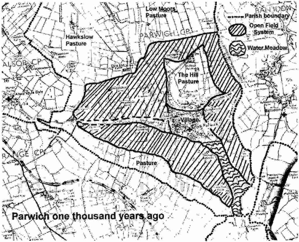
Parwich one thousand years ago
Below is Parwich’s entry in the Domesday Book. The Manor of Parwich consisted of the present parish of Parwich together with the outlying settlements of Alsop (now a separate parish), Hanson (later this became a monastic sheep ranch which developed into the present Hanson Grange Farm) and Cold Eaton (Eaton Dale no longer contains a settlement). The Manor belonged to the Crown and the land would have been let out. This meant that a number of families in the village were able to acquire some prominence and that the village was not as dominated by a single family.
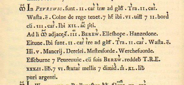
| In Parwich 2c of land taxable. Land for 2 ploughs. Waste. Coln holds from the King. He has 6 villagers and 2 smallholders with 3 ploughs Meadow, 12 acres. Attached to this manor are 3 outliers, ALSOP, HANSON and (cold) EATON. 2c of land taxable. Land for 2 ploughs. Waste These fivemanors. DARLEY< MATLOCK (Bridge) WIRKSWORTH ASHBOURNE and PARWICH with their outliers paid £32 and 6½ sesters of honey before 1066; now £40 pure silver. |
The people would have lived in much the same area as the present village. Though all we can identify, at present, is that the Church St. Peter’s, a common Anglo-Saxon dedication, is in the same location as the Saxon church, and that the Hall is likely to be on the site of the Saxon manor house. The areas around the Green and Nethergreen would have been quite boggy, so probably the focus of the village was on the higher ground by the Hall and the School. Some house names date from the beginning of the last millennium, such as Hallcliffe and Flaxdale, so it is possible that the current houses are on the site of the Anglo-Saxon dwellings of the same name.
The biggest difference would have been in the layout of the farmed land and the trackways. Farms werenot scattered across the parish as now, but people would travel out from the centre of the villageto large shared field areas. The crops were grown in plots in large expanses of ploughed land. These are called Open Fields, and a family may have strips or furlows in different parts of the field.The crops likely to have been grown were grains (wheat,barley and oats) and vegetables (peas, beans, cabbage, carrots, onions, parsnips and beetroot). We can still see the ‘ridge and furrow’ lines of the Saxon ploughing in theareas shownon the map overleaf, lookout for where they go straight through the modern fieldwalls. Also that flax was grown is indicated by the name Flaxdale which was in use by the 1200s. Livestock (cattle and sheep) wouldhave been grazed on the large common pastures that made up the bulk of the Parish.
Though there are many farms scattered through the parish now, a thousand years ago the ‘farmhouses’ would have been in the centre of the village. This is the likely reason why there were so many farms in the village up to just a few Years ago (for example Dam Farm, Flaxdale, Church Farm, Close Farm, Orchard Farm).
There was some water meadow in the parish, running down from the present sewage works towards White Meadow. The streams through the water meadow would have had sluice gates, which wouldhave been closed to flood the land in winter. The water then insulated the land from the cold, and when it was drained in the early spring it would be warmer than the surrounding land, resulting in earlier grazing.
The modern roads do not always follow the routes used a thousand years ago. The modern road tends to go along the valley bottoms, whereas the old trackways tend to follow the high ground. An example of the track following the higher ground is the Ringway, going north from Townhead, above the Newhaven road. It may be that the higher ground was used in winter, but as the ground dried out in summer the valley bottoms would have been used as well. Some of these ancient track ways, from frequent use and washing away of the soil, became ‘hollow ways’. that is, sunken tracks between high banks; examples of this can be seen in the villagesuch as Kiln Lane as it goes up from the Hall. The trackwaysaround Parwich have not been surveyed, and there is the opportunity to study this further
We do not know how old the water mill on the Alsop road (Dam Lane) would have been, nor do we know where the forge would have been a thousand years ago (Smithy Lane?). Was pottery made in the village? These are also things we may be able to find out.
Copyright © 2000 Peter Trewhitt

Leave a comment